|
Visitor Information - Menu

VISITOR INFORMATION - Visitors' Guide
CLICK HERE* for a PRINTABLE MAP (in Adobe Reader) of the Elliston & Maberly area.
The Elliston area has much to offer the visitor and the above printable map highlights points of interest. It is a useful aid to bring with you since wireless coverage is somewhat less than 100% in our area. We also recommend checking out Google maps (see below) as well as the Distance Finder provided by the Provincial Government. Here are few locations of interest but there are far more in our community, nevertheless, this makes for a good starting point.
Maberly to Little Catalina Trail (Printable Map Reference #1)
The "Maberly to Little Catalina Trail" provides one of the best hikes anywhere. It is 16.5 km in length and contains many items of interest such as the breath-taking scenery. Experience scenic Flower's Cove, the site of many a "boil up." Likewise, if hiking from the Little Catalina, note the rocks just offshore at the beginning of the trail known as the "Shag Rocks." This is the site of the shipwreck of the Ella Rudolph. From either starting the point this trail is something that must be seen to be appreciated.
The Puffin Train (Printable Map Reference #2)

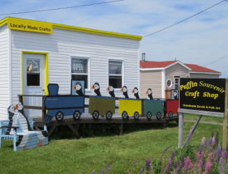
The Puffin Train is a colourful, yet unusual attraction located at Maberly, a short distance past the actual Puffin Viewing Site. It is a large mock-up of a train from the fictional puffin railroad featuring the Puffin Express. These cartoon like train cars have both puffin staff and passengers. There is even an empty place that serves as the perfect location for a person to include themselves as a passenger on the Puffin Express. It is a must see for the visitor that desires a fun, lighthearted souvenir photo and it’s free! If you like puffins it is surely something worth looking at! Also at this location is the Puffin Souvenir Craft Shop that offers a unique collection of handmade items that are made locally. It is one of those old fashion stores that you don’t see anymore. It has been built along the old-style pattern of stores that once existed throughout Newfoundland.
Movie Site & Fish Flake (Printable Map Reference #3)
See where scenes for the Grand Seduction, staring Taylor Kitsch, was filmed. A large replica fish flake is at this location that was also included in the film.
Lookout Site (Printable Map Reference #4)
The Maberly Look Out site was once known as Maberly Provincial Park for a very short time in its history. Today is nice spot to stop and view South Bird Island as well as a wonderful place to host a picnic.
Upstairs/Downstairs Root Cellars (Printable Map Reference #5 and best views are in the Maberly Loop Area)
The root cellar was the initial item that put Elliston, so to speak, on the map. A root cellar is a structure that was built in the days before electricity in order to keep vegetables from freezing in the winter months and to keep its contents cool during the warm summer months. They can be found all throughout our area and is Elliston’s original claim to fame although the upstairs/downstairs root cellars built in 1915 make for the best photos at this location.
Puffin Viewing Site (Printable Map Reference #6)
The puffin is the official bird of Newfoundland & Labrador and Elliston has one of the closest land views of puffins in North America. Our puffin viewing site is just a short five-minute walk from the main road and is also roughly halfway between Sandy Cove Beach and Puffin Train in Maberly. It is amazing to be able to walk up close to puffin and take some exceptional photos. Puffins return to the area in May and usually stay until the end of September. It is something worth checking out!
Municipal Park & Camp Ground (Printable Map Reference #7)
Elliston Municipal Park has hosted many picnics, outings, camping activities, festivals, and local special events. Over the years the park's infrastructure has been renovated to add a stage, related structures, fencing and upgraded camping lots to accommodate large RVs
Sandy Cove Beach (Printable Map Reference #8)
Elliston has many attractions to offer the visitor; however, one of its best natural features is its beautiful sandy beach. This beach boasts a freshwater brook, a refreshment stand, and nearby camping facilities at the municipal park.
Mini-Dungeon (Printable Map Reference #9)
Elliston has what many people may describe as a Mini-Dungeon (aka Blow Hole) located not too far from Sandy Cove. This hollow in the ground was caused through the process of erosion over many years and is similar to Bonavista's Dungeon but on a smaller scale.
Sealers Memorial Statue/Memorial Wall (Printable Map Reference #10)
A memorial statue, representation of father and son Reuben and Albert John Crewe, who froze to death during the 1914 SS Newfoundland Sealing Disaster, is located on Porter’s Point with its beautiful ocean vista. Although it depicts specific individuals it is representative of all sealing tragedies and is larger than life! It was constructed by renowned bronze sculptor and visual artist Morgan MacDonald. In addition, there is a Granite Memorial Wall listing all those lost during the SS Newfoundland Sealing Disaster and those aboard the SS Southern Cross that were all lost during the same tragic storm in 1914. It is another must see before leaving Elliston.
Post Office (Printable Map Reference #11)
Local Canada Post Office.
Elliston Recreation Centre & Playground (Printable Map Reference #12)
The Elliston Recreation Centre has hosted a great many local functions and has a beautiful mural painted along its entire length. The adjacent playground is a fun place for younger child to have a nice time.
Sealers Interpretation Centre (Printable Map Reference #13)
This is definitely a must see for those interested in the long and interesting history of the seal hunt in all its glory. Upon entering Elliston from any direction there is only one place to stop first – John C. Crosbie Sealers Interpretation Centre. It is centrally located on Main Street and you must pass it to reached Elliston’s well known Puffin Viewing Site and many other attractions. This thoroughly modern centre has a great deal of beautiful artwork, exceptional displays, handicap accessible washrooms and a special immersive area that will simulate standing offshore on an ice flow! Frankly, you will not see anything of this caliber outside of St. John’s and the Provincial “Rooms” museum/art gallery.
St. Mary's Anglican Church (Printable Map Reference #14)
Built in 1872 St. Mary's Anglican Church, in Elliston, is a good example of the Gothic Revival style and a registered historic site.
United Church (Printable Map Reference #15)
The United Church records show that construction on this church began in 1901 and was officially dedicated on May 18, 1902. The bell in the Elliston United Church was donated by Captain Abram Kean, an infamous character in the 1914 Newfoundland Disaster.
Coles' Gulch (Printable Map Reference #16)
Coles' Gulch was an important fishing area on the North Side of Elliston. A reconstruction of typical fish flake is located at this site.
Klondike Trail (Printable Map Reference #17)
The "Klondike Trail" located on the Northern section of town is well known. This trail was regularly used years ago as a horse and cart trail, leading from Elliston to the community of Spillars Cove. Today this trail provides a scenic walk for the adventurer.

Directions - How to find Elliston
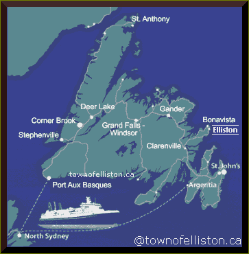
The town of Elliston is situated in Newfoundland & Labrador, the most easterly province in Canada. Specifically, we are located in Trinity Bay on the north eastern tip of the historic Bonavista Peninsula just a few minutes away from also historic Bonavista.
Elliston can be reached by turning off the Trans-Canada Highway in the vicinity of Clarenville onto Route 230A or 230. Travelling on 230 and turning off on 238 (entrance to Elliston) at the average speed of 69.4 km/h it will take 1 hour and 36 minutes traversing 111 km.
If you fly in at St. John’s International Airport and drive here it will take 3 hours and 33 minutes, at the average speed of 87.9 km/h, traversing 312 km. From Gander International Airport the drive will take 2 hours and 55 minutes, at the average speed of 82.6 km/h, traversing 241 km. Local taxi services regularly make trips to and from the capital city (St. John's).
The island of Newfoundland can also be accessed by sea. A link is maintained by Marine Atlantic between Nova Scotia and Newfoundland. During the summer, an additional run is provided between Argentia, Newfoundland and North Sydney, Nova Scotia. Elliston is 3 hours and 13 minutes, at the average speed of 83.3 km/h, traversing 268 km by road from the Marine Atlantic Ferry terminal in Argentia. It is 8 hours and 41 minutes, at the average speed of 92.3 km/h, traversing 809 km from the Port Aux Basques terminal.
| Back to Top | |
Elliston Community Website www.townofelliston.ca by NKT